Satellite view of Cyclone Yasi as a massive Category 5 spiral approaching Queensland
Catastrophe • 2011

Cyclone Yasi

The night the Wet Tropics went dark — and a World Heritage rainforest fell silent.

J
By Dr. Joshua Falken
8 April 202613 min read

On the night of 1 February 2011, residents across Far North Queensland had already packed what they could carry and driven inland. The Bureau of Meteorology had been unambiguous for two days: Cyclone Yasi was going to be the most powerful storm to strike the Queensland coast in living memory. The warnings worked. But no warning could prepare the land itself.

By midnight, Yasi's outer bands were shredding the Mission Beach coastline. The towns of Innisfail, Cardwell, Tully, and Mission Beach had been emptied with remarkable efficiency. What the storm found when it arrived was a landscape — and an ecosystem — utterly alone in the dark.

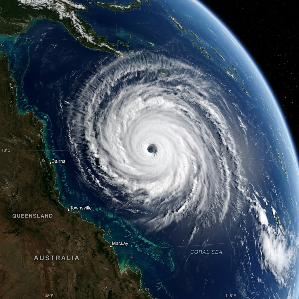
At approximately midnight AEST, Yasi's eye crossed the coast between Mission Beach and Cardwell as a Category 5 severe tropical cyclone. Its central pressure of 929 hPa made it the most intense tropical cyclone to make landfall in Queensland since 1918. Sustained winds of 285 km/h, gusting beyond 300 km/h, tore through the coastal strip. A storm surge of up to five metres inundated the beachfront. The Wet Tropics World Heritage Area — one of Earth's oldest rainforests — took the full force of the eye wall.
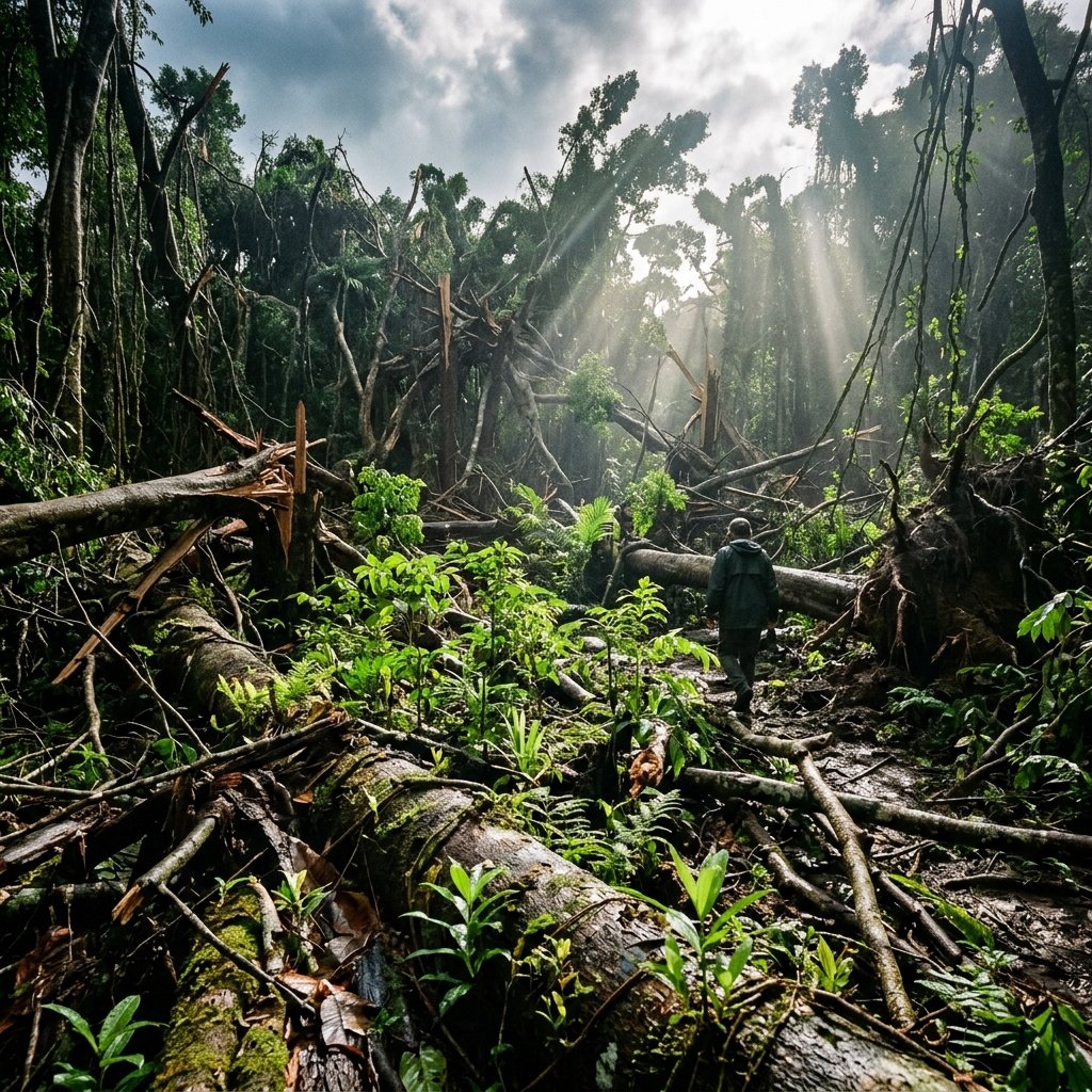
We thought we understood these forests. They’re hundreds of millions of years old. But when we walked in after Yasi, it was like walking on another planet. The canopy was simply gone.

— Dr. Erin Vandermark, Wet Tropics Authority, February 2011

A Storm of Record Force

Cyclone Yasi earned its place in the record books not only for its intensity but for its sheer physical scale. At peak intensity, its gale-force wind radius extended over 650 kilometres — large enough to simultaneously affect Cairns to the north and Townsville to the south, covering an area greater than the United Kingdom.

Destroyed Wet Tropics rainforest after Cyclone Yasi — trees snapped, canopy stripped, early green regrowth visible on forest floor
The Canopy Gone Wet Tropics rainforest in the days after Yasi — ancient trees snapped at the trunk, the forest floor exposed to sky for the first time in a century.
Click to expand

An Extraordinary Evacuation

An estimated 175,000 people evacuated from low-lying coastal areas. The death toll — one confirmed direct fatality from storm surge — reflected what can be achieved when warnings are clear and heeded. Post-event surveys confirmed that had the population not evacuated, the death toll could have been in the hundreds given the extent of building damage.

The Agricultural Reckoning

Just five years after Cyclone Larry obliterated the banana crop, Yasi struck the same region. An estimated 75 per cent of Australia’s banana crop was again destroyed. Sugar cane fields across the Tully and Innisfail districts were flattened. Total economic damage reached A$3.6 billion — more than double the cost of Larry.

parkImpact Story — Environmental

The World Heritage Area in the Eye of the Storm

“I stepped into the forest two weeks later and I burst into tears. The trees I’d studied for fifteen years — gone. But then I looked closer. There were seedlings already. The forest was fighting back.”

— Dr. Sarah Laurance, Tropical Forests Research Centre, March 2011

The Wet Tropics of Queensland World Heritage Area is one of Earth’s oldest continuously existing rainforests — a living remnant of Gondwana, the ancient supercontinent. It harbours over 3,000 plant species and 107 mammal species. When Cyclone Yasi’s eye wall crossed this landscape at 285 km/h, it radically changed the canopy structure of an ecosystem that had taken millions of years to develop.

In the immediate aftermath, over 90,000 hectares of the World Heritage Area sustained damage ranging from heavy canopy thinning to catastrophic canopy loss. Rain trees that had stood for centuries were snapped at the base. The forest floor, normally in perpetual tropical twilight, was suddenly bathed in sunlight.

The Great Barrier Reef also felt Yasi’s force. The storm surge and wave action caused physical damage to coral formations along the inshore reef, particularly in the Hinchinbrook Channel. Freshwater runoff carrying soil, debris, and agricultural chemicals flooded coastal waters, clouding conditions that coral needs to survive.

Yet the story of the Wet Tropics after Yasi is ultimately one of extraordinary resilience. Within weeks, fast-growing pioneer species had begun colonising the broken canopy. The forest’s ancient DNA contained the instructions for rebuilding — it had survived ice ages and hundreds of previous cyclones. It would survive this one too.

lightbulb

Learning Focus: Ecosystem Vulnerability & Recovery

Natural disasters reveal how ecosystems respond to sudden, extreme stress. Understanding this helps us protect environments before and after disaster strikes.

  • check_circleWorld Heritage Areas are places of such extraordinary natural or cultural value they are protected under international law. The Wet Tropics is one of the most biologically unique on Earth — many species here exist nowhere else.
  • check_circleEcological resilience is the ability of an ecosystem to absorb disturbance and reorganise. Ancient rainforests have evolved to recover from cyclones over millions of years — they are more resilient than most human-built environments.
  • check_circleClimate change is increasing the frequency and intensity of Category 4 and 5 cyclones. If ecosystems face more frequent extreme events, they may not have enough time to recover between each one, gradually weakening their resilience.
  • check_circleCoral bleaching occurs when stress causes coral to expel the algae that give it colour and nutrition. Cyclone runoff, combined with warming oceans, puts Australia’s reef systems at serious long-term risk.
The Aftermath

Coast in Ruin

Imagery from the Mission Beach and Cardwell districts in the days following landfall. The storm surge and wind destruction reshaped the coastline.

Destroyed Wet Tropics rainforest after Cyclone Yasi — trees snapped, canopy stripped
Figure 1.1

The rainforest canopy, centuries in the making, stripped bare within hours.

Aerial view of Mission Beach coast after Cyclone Yasi storm surge — buildings flooded, palm trees stripped bare
Figure 1.2

The 3–5 metre storm surge dissolved the boundary between sea and township.

Meteorological Record

Track of the Storm

Bureau of Meteorology records mapping Cyclone Yasi's track from east of Vanuatu to its Category 5 landfall near Mission Beach.

Bureau of Meteorology track map for Cyclone Yasi — path from Vanuatu to Mission Beach Queensland
Figure 2.1

Track map — Yasi's path from origin to Category 5 landfall. © Bureau of Meteorology 2011.

Rainfall distribution across Far North Queensland during Cyclone Yasi
Figure 2.2

Rainfall distribution — totals exceeding 300 mm in the Mission Beach and Tully regions within 24 hours.

Media Record

The Front Pages

Australia’s media captured the scale of Yasi’s landfall in real time. The story of 175,000 evacuees and a nation holding its breath dominated every front page on 2 February 2011.

The Australian

“Monster Yasi Hits — 175,000 Flee”

2 February 2011 — The nation’s leading broadsheet captured the unprecedented evacuation as Australia’s biggest peacetime civil defence operation unfolded across Far North Queensland.

2 Feb 2011
The Cairns Post

“The Night Yasi Came”

3 February 2011 — The local paper’s special edition, with first images from the impact zone as communications were slowly restored to the devastated coastal strip.

3 Feb 2011
The Sydney Morning Herald

“The Rainforest’s Long Road Back”

March 2011 — A feature on ecological recovery examining how scientists began documenting the World Heritage Area’s extraordinary response to the storm.

March 2011