A forward look at how heavier bursts of rain, higher seas, and denser cities are reshaping risk—and the kinds of prevention and mitigation tools planners are turning to next.
1. The Climate Science
The scientific consensus regarding Australia's future weather patterns is clear. According to the Bureau of Meteorology and CSIRO's State of the Climate reports, while total annual rainfall may vary, the intensity of heavy, short-term rainfall events is projected to increase. A warmer atmosphere holds more moisture, meaning that when it rains, it has the potential to rain much harder.
Furthermore, sea levels are rising globally. For a estuarine city like Brisbane, this is not a distant abstract threat. A higher baseline sea level means that high tides become higher, increasing the frequency of extreme storm tides and exacerbating tidal backing during riverine floods.[1]
2. The Compound Event Paradigm
Historically, flood planning relied on assessing risks from single mechanisms—analyzing river data in isolation, or storm surge data in isolation. The 2022 flood fundamentally shifted this approach. It highlighted the devastating reality of the compound flood.
When saturated soils, intense creek rainfall, a swollen main river, and an incoming high tide all align, the traditional risk maps become inadequate. This is the new paradigm for urban flood management.
3. Global Context and Local Resilience
Brisbane's challenge is not unique. From the 1953 North Sea disaster that prompted the Netherlands to build the Delta Works, to the lethal 2021 floods in Western Germany's small catchments, cities globally are recognizing that historical data is no longer a reliable predictor of future risk. In the language of the United Nations Intergovernmental Panel on Climate Change (IPCC), disaster risk is the intersection of a natural hazard interacting with human exposure and vulnerability.
The logical response is to invest aggressively in resilience. The Queensland Reconstruction Authority notes that every dollar spent on preparedness, better zoning, early warning systems, and resilient infrastructure saves several dollars in post-disaster recovery. Following both 2011 and 2022, Queensland updated its flood mapping and planning codes, attempting to ensure that new developments are less exposed.
4. The Ultimate Challenge
The hardest problem facing South East Queensland is growth. The region's population is expanding rapidly, placing immense pressure to build more housing on the very floodplains that nature occasionally reclaims. The "exposure" dimension of the risk equation is growing faster than the "resilience" dimension can catch up.
The Brisbane River will flood again. It is a fundamental truth of the city's geography. The only variable remaining is how deeply the lessons of 1893, 1974, 2011, and 2022 have been learned, and how well prepared the city will be when the river rises once more.
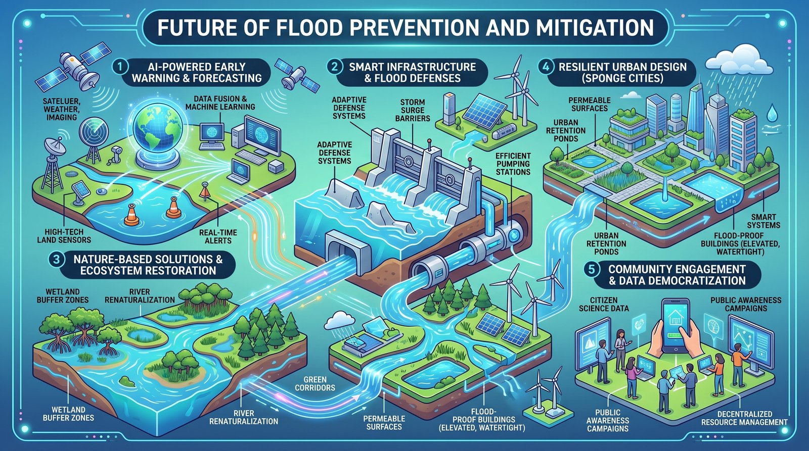
5. Flood prevention and mitigation
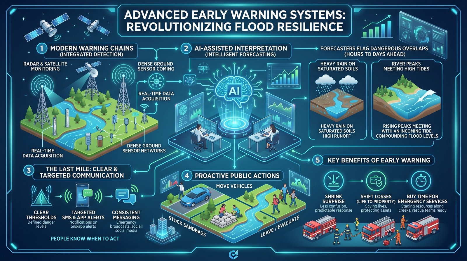
AI-powered early warning and forecasting
Forecasting chains now blend satellite and radar imagery, high-resolution land sensors, and river and tide gauges, with machine-learning layers that fuse noisy inputs into clearer short-range projections. That stack supports graded alerts when several hazards align—intense rain on saturated soils, or a river peak sliding toward a high tide—so emergency managers can pre-position crews and the public can act early. The last mile remains human: plain thresholds, targeted SMS and app pushes, and consistent advice on what to move, where not to drive, and when to leave. Warnings do not stop floods, but they shrink surprise and buy minutes to hours that matter most when creeks rise as fast as they did in 2022-style bursts.
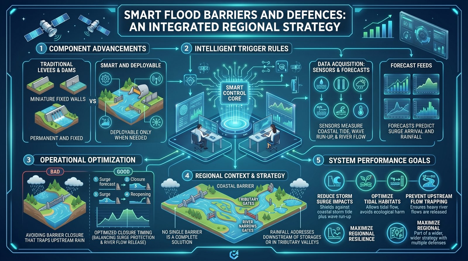
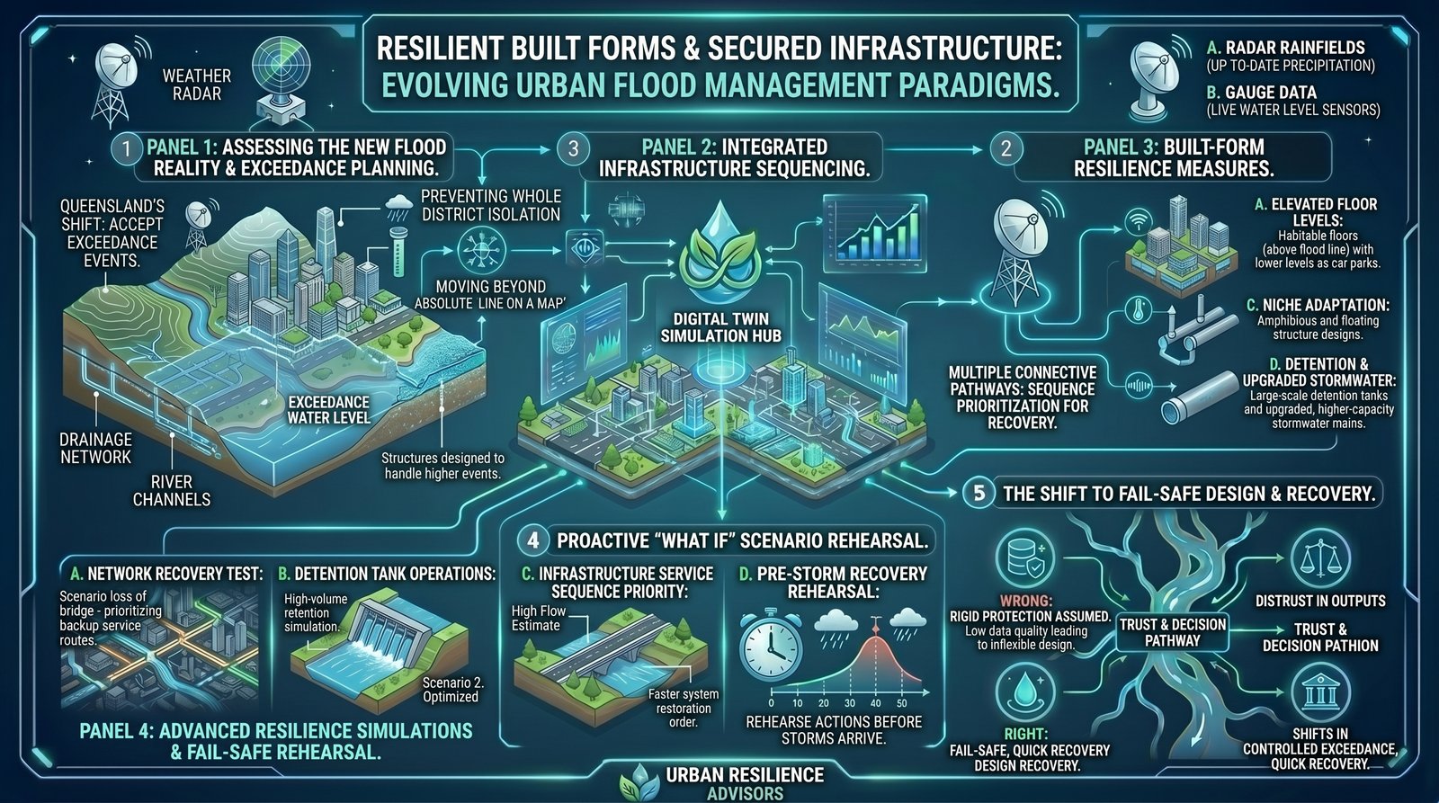
Smart infrastructure and flood defences
Beyond static levees, “smart” defences pair movable gates and storm-surge barriers with rules driven by live forecasts—closing only when needed and reopening so upstream rainfall is not trapped. Large pumping stations and upgraded drainage outfalls are part of the same picture where backflow would otherwise pond in low-lying grids. Renewable generation nearby does not stop water, but it can keep telemetry, pumps, and control rooms alive when the wider grid is stressed. In the lower Brisbane estuary, such hardware must sit inside a catchment-wide plan: no barrier intercepts rain that falls downstream of major storages or in tributary valleys that never see the main river gate.
Nature-based solutions and ecosystem restoration
Wetland buffer zones, river renaturalisation with meanders and woody debris, and continuous green corridors slow runoff, store water temporarily, and shave peak discharges before they reach concrete channels. Mangrove and saltmarsh edges also dampen wave energy where storm tide meets river flow. These measures rarely replace major engineering, but they improve water quality, reduce maintenance on hard banks, and create cooler, more liveable corridors—co-benefits that help justify land set-asides in a city competing for every hectare of floodplain fringe.
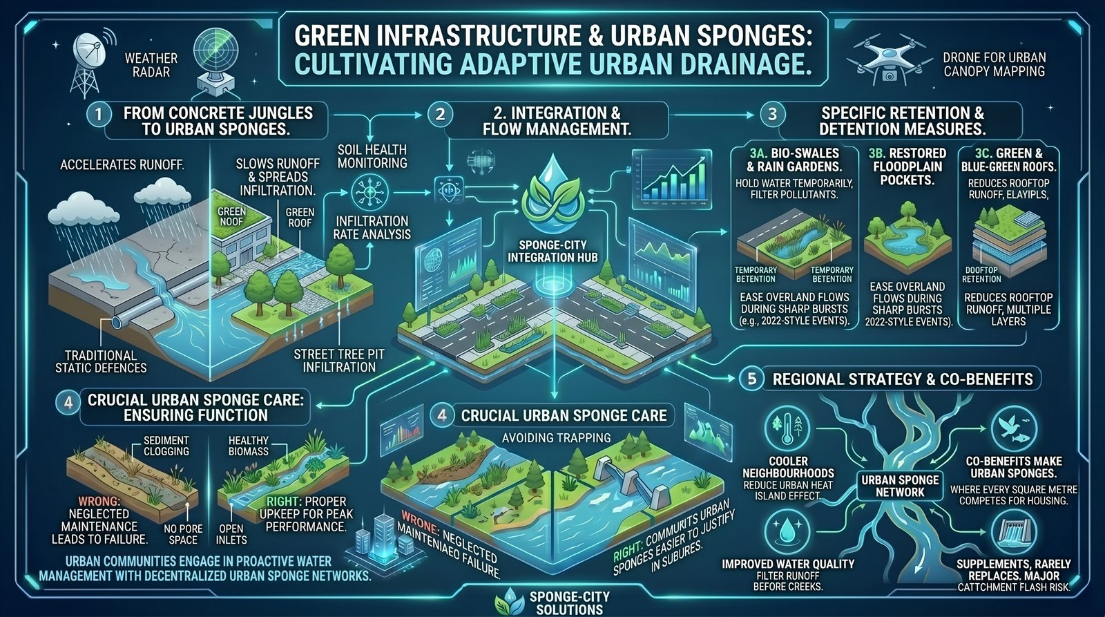
Resilient urban design (sponge cities)
Sponge-city design threads permeable surfaces, bioswales, street trees, and urban retention ponds through the street grid so rainfall is held, filtered, and released slowly rather than sheet-flowing to the nearest pipe. Buildings combine green roofs and elevated, watertight ground levels with “smart” services—sensors and valves that report inundation risk to owners and insurers. That package targets the compound 2022 lesson: most affected properties were creek- and overland-dominated, not river-gauge icons. Layered urban sponging will not erase risk, but it lowers the odds that a sub-hour burst overwhelms every downstream opening simultaneously.
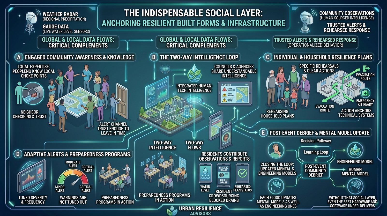
Community engagement and data democratisation
Hardware and models only work when residents understand them, trust them, and can feed them ground truth. Citizen-science rainfall and creek observations, photograph-based damage reporting, and open dashboards for river and tide levels widen who can “read” the emergency. Public-awareness campaigns and rehearsed household plans translate forecasts into action, while clearer rules for decentralised sandbag hubs, evacuation routes, and mutual aid reduce single points of failure. Without that social and data layer, even perfect satellites and pumps under-deliver—because risk, in the end, is still people, assets, and decisions in real suburbs.